- Aerobics
- Air Combat
- Airships
- Archery
- Badminton
- Ballroom Dancing
- Bars
- Baseball
- Basketball
- Baton Twirling
- Beer Brewing
- Bi-Plane Flight
- Bicycle Rental
- Billiards
- Bird Watching
- Boat Hire
- Bocce Ball
- Bowling
- Boxing
- Bungee Jumping
- Cage Fighting
- Camping
- Canoeing
- Canyoning
- Card Trading
- Cheerleading
- Cinema
- Circuit Training
- Comics
- Cooking Class
- Cricket
- Croquet
- Cross Country Running
- Cross Country Skiing
- Cruising
- Cup Stacking
- Curling
- Cycling - Road
- Dancing
- Dancing - Latin
- Dancing - Morris
- Darts
- Deep Sea Fishing
- Dinner Cruises
- Disc Golf
- Discus
- Diving
- Dolphin Experiences
- Downhill Skiing
- Dragsters
- Dressage
- Dune Buggies
- English Pubs
- Falconry
- Fencing
- Fishing
- Fly Fishing
- Flying Lessons
- Football
- Frog Jumping
- Gambling
- Gaming
- Gardens
- Geocacheing
- Glass Blowing
- Gliding
- Golf
- Gondola Rides
- Gymkhana
- Gymnastics
- Hacky Sack
- Handball
- Hang Gliding
- High Jump
- Hiking
- Hockey
- Horse Jumping
- Horse Racing
- Horseback Riding
- Horseshoe Pitching
- Hot Air Ballooning
- Hovercrafts
- Hunting
- Ice Hockey
- Inline Skating
- Irish Dancing
- Irish Pubs
- Jai Alai
- Javelin
- Jazz Playing
- Jet Experiences
- Jigsaw Puzzles
- Juggling
- Karting
- Kayaking
- Kick Boxing
- Kickball
- Kite Surfing
- Lacrosse
- Laser Tag
- Lawn Bowling
- Lifting
- Little League
- Long Jump
- Luge
- Marching
- Marinas
- Martial Arts
- Model Airplanes
- Model Railroads
- Motor Cross
- Mountain Biking
- Mountain Climbing
- Movies
- NASCAR Driving
- Off-Roading
- Orienteering
- Paddleball
- PADI Courses
- Paintball
- Philately
- Photography
- Pilates
- Polo
- Pottery
- Race Car Driving
- Racquetball
- Restaurants
- Robot Wars
- Rock Climbing
- Roller Derby
- Roller Hockey
- Roller Skating
- Rollercoasters
- Rope Jumping
- Rowing
- Rugby
- Running - Road
- RV Parks
- RV Rentals
- Safari
- Sailing - Hobie Cats
- Sandboarding
- Scenic Flights
- Scenic Train Rides
- Scrapbooking
- Scuba Diving
- Segway Tours
- Shuffleboard
- Skateboarding
- Skating
- Ski Jumping
- Skiing
- Skimobiling
- Sky Diving
- Sledding
- Snorkeling
- Snow Parks
- Snowboarding
- Snowmobiling
- Snowshoeing
- Soccer
- Softball
- Spa
- Squash
- Stamp Collecting
- Sudoku
- Sumo Wrestling
- Surfing
- Swimming
- Table Tennis
- Tai Chi
- Tennis
- Theater
- Theme Parks
- Tiddlywinks
- Tight Rope
- Toboggan
- Track/Field
- Trampoline
- Trap/Skeet
- Unicycle
- Volleyball
- Wakeboarding
- Walking
- Wallyball
- Warhammer 40K
- Water Aerobics
- Water Jogging
- Water Polo
- Water Skiing
- Waterparks
- Weight training
- Whale Watching
- Whitewater Rafting
- Wine Making
- Wine Tasting
- Wrestling
- Yoga
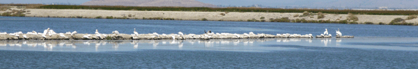
Bird Watching
Pea Island National Wildlife Refuge - Hwy 12, Manteo, NC 27954
INvite | Map It | Location Owner? | RAP
Distance: Enter your Zip Code or Log-in
Date Added: Jun 02, 2010
Phone Number: 252-987-1118
Website: www.fws.gov/peaisland
Log-in to rate.
Write a review
Description: Pea Island National Wildlife Refuge is known as a ''Birder's Paradise.' The refuge, established in 1937, is located on the north end of Hatteras Island, a barrier island on North Carolina’s Outer Banks.
Pea Island National Wildlife Refuge is comprised of ocean beach, dunes, upland, fresh and brackish water ponds, salt flats, and salt marsh. The bird list boasts more than 365 species. Concentrations of ducks, geese, swans, wading birds, shore birds, raptors, and tropical migrants are seasonally abundant on the refuge. Several shorebird nesting areas and wading bird rookeries are located on the refuge. Endangered and threatened species include peregrine falcons, loggerhead sea turtles, and piping plovers.
Directions: From Norfolk and Currituck Area:
Take US 168 south. US 168 becomes US 158 about 18 miles south of the NC/VA line. Continue on US 158 for about 23 miles. At this point you will cross the Wright Memorial Bridge across the Currituck Sound. After the bridge continue on US 158 through Kitty Hawk, Kill Devil Hills, and Nags Head. At the south end of Nags Head, you will see signs for Hatteras Island, Cape Hatteras National Seashore, and NC 12 south. You will make a left at a traffic light onto NC 12 south. Almost immediately you will pass through another traffic light and will now be on NC 12 south. Follow NC 12 south for approximately 8 miles. Cross the Herbert C. Bonner Bridge across Oregon Inlet. On the south side of the bridge you will see the refuge entrance sign on your right. Approximately 4 miles south on the right is the Visitor’s Center and an informational kiosk providing information on trails and visitor opportunities.
From Raleigh Area:
Take US 64 east from Raleigh. Travel east on US 64 for approximately 3 hours (at posted highway speeds). Approximately 12 miles west of the town of Columbia, US 64 will cross the Alligator River. On the east side of the bridge you will see a sign for Alligator River National Wildlife Refuge. Continue east through this refuge on US 64. US 64 will join with US 264 to become US 64/264. Continue east through the town of Manns Harbor on US 64/264 and cross the bridge to Roanoke Island. Here you will continue east on US 64/264 across 1 tall bridge and 1 small bridge. After the small bridge you will see signs for Hatteras Island, Cape Hatteras National Seashore, and NC 12 south. Take a right onto NC 12 south. Follow NC 12 south for approximately 8 miles. Cross the Herbert C. Bonner Bridge across Oregon Inlet. On the south side of the bridge you will see the refuge entrance sign on your right. Approximately 4 miles south on the right is the Visitor Center and an informational kiosk providing information on trails and visitor opportunities.
Reviews:
No reviews have been written yet. Write one now.
- My News
Chat with other TryItOnce members - My Teams
Click here to manage your activity teams - Try It Once!
Purchase a gift certificate to try an activity - Articles
Read articles about your favorite activities - What's On Sale
Gear you need at great prices - Facebook Connect
Access TryItOnce with your Facebook account - Location Owners
Manage your own business on TryItOnce -
Weekly Newsletter Sign-Up
- Add Location
Add a new location to TryItOnce - New Team?
Click here to create a team for your activity - Submit Article
Submit an article about your favorite activity